Bangalore(Namma) Metro Route from Kempegowda Majestic to Sandal Soap Factory

Bangalore Metro Route from Kempegowda Majestic to Sandal Soap Factory Fare and Timing

Traveling by Bangalore Metro has become one of the fastest and most convenient ways to get around the city. One popular route among daily commuters and tourists alike is from Kempegowda Majestic to Sandal Soap Factory station.

The Sandal Soap Factory station lies on the Green Line of Namma Metro and connects efficiently with the central hub at Kempegowda Majestic, which is an interchange station for both the Purple and Green Lines. This route is well-frequented, especially by those heading towards the Peenya Industrial Area and other nearby localities.

The metro fare from Kempegowda Majestic to Sandal Soap Factory typically ranges between ₹15 to ₹20, depending on the ticket type (single journey, return, or smart card). The total travel time is approximately 10–12 minutes, with trains operating every 5–8 minutes during peak hours.

Metro services run from around 5:00 AM to 11:00 PM daily, making it highly accessible for early commuters and late travelers. Whether you’re heading to work, exploring nearby attractions, or simply passing through, the Sandal Soap Factory metro station offers a quick and efficient transit option.

Enjoy hot and hygienic food in train with Travelkhana. We provide food delivery in train from trusted brands like Barbeque Nation, Faasos, and Pizza Hut. Available across 250+ stations, airports, and offsite locations. Order from the Travelkhana app today!

Fare22
Time12
Stations6
Interchange Stations0


Stations
■ Kempegowda Majestic
■ Mantri Square Sampige Road
■ Srirampura
■ Kuvempu Road
■ Rajajinagar
■ Mahalakshmi
■ Sandal Soap Factory

Nearest Metro Station to Christian Institute of Management

If you’re looking to visit the Christian Institute of Management in Bangalore, taking the Namma Metro is a smart and convenient choice. The nearest metro station to Christian Institute of Management is Indiranagar Metro Station, located on the Purple Line of the Bangalore Metro.

The Indiranagar Metro Station is approximately 1.5 to 2 kilometers from the institute, making it easily accessible via a short auto-rickshaw or cab ride. The station is well-connected to various parts of Bangalore, including MG Road, Majestic, and Baiyappanahalli, allowing for quick and hassle-free travel.

Trains on the Purple Line run frequently, with services available every 5 to 10 minutes during peak hours. Metro services typically operate from 5:00 AM to 11:00 PM daily. The fare to Indiranagar varies based on your starting station but generally ranges from ₹10 to ₹40.

Using the metro to reach the Christian Institute of Management is both time-saving and economical, especially compared to road travel during Bangalore’s peak traffic hours.

Nearest Metro station to National Heart Institute (Delhi)

Nearest Metro Station to National Heart Institute (Delhi)

If you’re planning a visit to the National Heart Institute in Delhi and prefer metro travel, you’re making a smart choice. The nearest metro station to National Heart Institute is Kailash Colony Metro Station, located on the Violet Line of the Delhi Metro. It is approximately 1 km from the hospital and takes around 5 to 10 minutes to reach via auto or e-rickshaw.

The National Heart Institute is a reputed cardiac care center situated in East of Kailash, South Delhi. Due to its location in a busy and well-connected area, using the Delhi Metro is the fastest and most economical mode of travel. From Kailash Colony Metro Station, you can either walk if comfortable or take a quick ride to the institute.

Travelers coming from other parts of Delhi NCR can conveniently interchange at central hubs like Mandi House, Central Secretariat, or Lajpat Nagar to get onto the Violet Line.

For patients and visitors, especially during rush hours, metro travel to National Heart Institute ensures timely arrival without the stress of traffic or parking. Make sure to plan your route ahead using the Delhi Metro app or map.

Planning a trip? Get your favorite food in train delivered to your seat by Travelkhana. We offer quick and reliable food delivery in train from McDonald’s, Behrouz Biryani, and more. Also delivering at airports and offsite venues. Download now: 

Route to reach National Heart Institute (Delhi) from Kashmere Gate Metro Station

To reach the National Heart Institute from Kashmere Gate Metro Station, board the Violet Line of Delhi Metro. First, take the Red Line from Kashmere Gate to Mandi House. From Mandi House, interchange to the Violet Line and head towards Kailash Colony Metro Station, which is the nearest metro station to this Institute. The distance from Kailash Colony to the hospital is just about 1 km, and you can easily reach the hospital in 5 to 10 minutes by auto or e-rickshaw. The total journey by metro takes around 30 to 35 minutes. This is one of the most efficient and budget-friendly routes to reach this Institute in South Delhi.

Normal Fare40
Concessional Fare( For Sunday & National Holiday )30
Timing – 30 MinStations – 14Interchange – 0
Route
Kashmere Gate
Lal Quila
Jama Masjid
Delhi Gate
ITO
Mandi House
Janpath
Central Secretariat
Khan Market
JLN STADIUM
Jangpura
Lajpat Nagar
Moolchand
Kailash Colony

Route to reach National Heart Institute (Delhi) from Noida City Center Metro Station

Normal Fare40
Concessional Fare( For Sunday & National Holiday )30
Timing – 40 MinStations – 13Interchange – 2
Route
NOIDA CITY CENTRE
Golf Course
Botanical Garden <Change Here>
Okhla Bird Sanctuary
Kalindi Kunj
Jasola Vihar
Okhla Vihar
Jamia Milia Islamiya
Sukhdev Vihar
NSIC Okhla
Kalkaji Mandir <Change Here>
Nehru Place
Kailash Colony

Route to reach National Heart Institute (Delhi) from Vaishali Metro Station

Normal Fare50
Concessional Fare( For Sunday & National Holiday )40
Timing – 46 MinStations – 19Interchange – 1
Vaishali
Kaushambi
Anand Vihar
Karkar Duma
Preet Vihar
Nirman Vihar
Laxmi Nagar
Yamuna Bank
Indraprastha
Pragati Maidan
Mandi House <Change Here>
Janpath
Central Secretariat
Khan Market
JLN STADIUM
Jangpura
Lajpat Nagar
Moolchand
Kailash Colony

Route to reach National Heart Institute (Delhi) from Rithala Metro Station

Normal Fare50
Concessional Fare( For Sunday & National Holiday )40
Timing – 62 MinStations – 22Interchange – 2
Route
Rithala
Rohini West
Rohini East
Pitam Pura
Kohat Enclave
Netaji Subhash Place <Change Here>
Shakurpur
Punjabi Bagh West
ESI Hospital
Rajouri Garden
Mayapuri
Naraina Vihar
Delhi Cantt.
South Campus
Sir Vishweshariah Moti Bagh
Bhikaji Cama Place
Sarojini Nagar
INA
South Extension
Lajpat Nagar <Change Here>
Moolchand
Kailash Colony

Route to reach National Heart Institute (Delhi) from Huda City Center chowk

Normal Fare50
Concessional Fare( For Sunday & National Holiday )40
Timing – 55 MinStations – 20Interchange – 2
Route
Huda City Centre
IFFCO Chowk
M G Road
Sikandarpur
Guru Dronacharya
ArjanGarh
Ghitorni
Sultanpur
Chhattarpur
Qutab Minar
Saket
Malviya Nagar
Hauz Khas
Green Park
AIIMS
INA <Change Here>
South Extension
Lajpat Nagar <Change Here>
Moolchand
Kailash Colony

Nearest Metro Station to Rajdhani College

Nearest Metro Station to Rajdhani College

About Rajdhani College: Rajdhani College is a constituent college of the University of Delhi and has proudly completed over 50 years of academic excellence. Established in 1964 by the Delhi Administration, it was originally set up in Kirti Nagar, New Delhi, and is recognized as a Government College. The campus is located in West Delhi along Ring Road, near Raja Garden.

College Address:
Block C, Mahatma Gandhi Marg, Raja Garden, New Delhi – 110015.

One of the most appealing aspects of Rajdhani College is its strategic location. It is easily accessible from various parts of Delhi, including nearby metro stations like Ramesh Nagar and Rajouri Garden, which are just a short walk from the college. This prime location adds to its popularity among students, alongside its reputation for academic excellence.

Nearest Metro Station: Planning to visit Rajdhani College? The most convenient way to reach is via Delhi Metro, known for being affordable and comfortable for daily commutes across Delhi NCR. The nearest metro station to Rajdhani College is Rajouri Garden Metro Station. It is well-connected and accessible from multiple areas of Delhi, offering a hassle-free travel experience for both students and visitors.

Craving good food in train? Travelkhana delivers meals from the best brands—Biryani Blues, Haldiram’s, and Faasos. Get food delivery in train, at airports, and event sites nationwide. Try Travelkhana and taste the difference:

Route to reach Rajdhani College from Kashmere Gate Metro Station:-

Looking for the best way to reach Rajdhani College from Kashmere Gate Metro Station? The road distance between the two is approximately 16 km, which takes around 40 minutes by car, cab, or bus depending on traffic conditions.

The nearest metro station to Rajdhani College is Rajouri Garden Metro Station, an important interchange between the Blue Line and Pink Line of the Delhi Metro. Traveling by metro is a much more efficient option—covering the distance from Kashmere Gate to Rajouri Garden in about 30 minutes.

Once you reach Rajouri Garden Metro Station, Rajdhani College is just 1 km away, and it takes only 5 minutes to reach by foot, e-rickshaw, or auto-rickshaw.

For daily commuters, the Delhi Metro is the most convenient, economical, and time-saving option compared to road travel.

Rajdhani College, established in 1964, is a well-known institution affiliated with the University of Delhi. Located on Mahatma Gandhi Marg, the college offers a wide range of undergraduate and postgraduate programs across multiple disciplines.


Normal Fare (Rs.)40
Concessional Fare (Rs.)30
Time38 min
First5:59
Last23:17
From Platform0:00
Get down onRight
#StationPhone
1Kashmere Gate8800793107
2Chandni Chowk8800793130
3Chawri Bazar8800793131
4New Delhi8800793132
Interchange
5New Delhi-Airport Express8800793132
6Shivaji Stadium
7Dhaula Kuan
Interchange
8Durgabai Deshmukh South Campus
9Delhi Cantt
10Naraina Vihar
11Maya Puri
12Rajouri Garden

Route to reach Rajdhani College from Noida City Center Metro Station

Looking for directions to Rajdhani College from Noida City Center Metro Station? The total distance is approximately 33.2 km by road, and it typically takes around 1 hour and 5 minutes to reach by car or private cab via Mahatma Gandhi Marg and Ring Road, depending on traffic conditions. And Metro travel takes around 1 hour, with a fare of just ₹50, making it a smart and budget-friendly choice.

For a faster and more economical option, the Delhi Metro is highly recommended. Board the Blue Line metro from Noida City Center heading towards Dwarka Sector 21, and get down at Ramesh Nagar Metro Station. From there, Rajdhani College is located just 800 meters away, which can be covered in about 10 minutes on foot or by e-rickshaw/auto.

Normal Fare (Rs.)50
Concessional Fare (Rs.)40
Time57 min
First6:00
Last23:05
From Platform0:00
Get down onLeft
#StationPhone
1Noida City Center8800793155
2Golf Course8800793156
3Botanical Garden8800793157
4Noida Sector-188800793158
5Noida Sector-168800793159
6Noida Sector-158800793160
7New Ashok Nagar8800793161
8Mayur Vihar Extention8800793162
9Mayur Vihar Phase-18800793163
10Akshardham8800793164
11Yamuna Bank8800793165
12Indraprastha8800793166
13Pragati Maidan8800793167
14Mandi House8800793168
15Barakhamba8800793169
16Rajiv Chowk8800793133
17R K Ashram Marg8800793170
18Jhandewalan8800793171
19Karol Bagh8800793172
20Rajendra Place8800793173
21Patel Nagar8800793174
22Shadipur8800793175
23Kirti Nagar8800793176
24Moti Nagar8800793177
25Ramesh Nagar8800793178
26Rajouri Garden8800793179

Route to reach Rajdhani College from Vaishali metro Station

Normal Fare (Rs.)50
Concessional Fare (Rs.)40
Time51 min
First6:00
Last23:05
From Platform0:00
Get down onLeft
#StationPhone
1Vaishali8800793236
2Kaushambi8800793235
3Anand Vihar8800793198
4Karkar Duma8800793199
5Preet Vihar8800793200
6Nirman Vihar8800793201
7Laxmi Nagar8800793202
8Yamuna Bank8800793165
9Indraprastha8800793166
10Pragati Maidan8800793167
11Mandi House8800793168
12Barakhamba8800793169
13Rajiv Chowk8800793133
14R K Ashram Marg8800793170
15Jhandewalan8800793171
16Karol Bagh8800793172
17Rajendra Place8800793173
18Patel Nagar8800793174
19Shadipur8800793175
20Kirti Nagar8800793176
21Moti Nagar8800793177
22Ramesh Nagar8800793178
23Rajouri Garden8800793179

Route to reach Rajdhani College from Rithala metro Station

Normal Fare (Rs.)30
Concessional Fare (Rs.)20
Time27 min
First5:25:00
Last22:34
From Platform0:00
Get down onRight
#StationPhone
1Rithala8800793120
2Rohini West8800793119
3Rohini East8800793118
4Pitam Pura8800793117
5Kohat Enclave8800793116
6Netaji Subhash Place8800793115
Interchange
7
Netaji Subhash Place
8Shakurpur
9
Punjabi Bagh West
10ESI Hospital
11Rajouri Garden

Route to reach Rajdhani College from Huda City Centre Metro Station

Normal Fare (Rs.)60
Concessional Fare (Rs.)50
Time1:19 hr
First5:45
Last22:36
From Platform0:00
Get down onLeft
#StationPhone
1Huda City Centre8800793154
2IFFCO Chowk8800793153
3MG Road8800793152
4Sikandarpur8800793151
5Guru Dronacharya8800793150
6Arjan Garh8800793149
7Ghitorni8800793148
8Sultanpur8800793147
9Chhattarpur8800793146
10Qutab Minar8800793145
11Saket8800793144
12Malviya Nagar8800793143
13Hauz Khas8800793142
Interchange
14Hauz Khas8448991345
15IIT Delhi8448991346
16R.K Puram8448991347
17Munirka8448991348
18Vasant Vihar8448991349
19Shankar Vihar8448991350
20Terminal 1 IGI Airport8448991351
21Sadar Bazaar Cantonment8448991352
22Palam8448991353
23Dashrath Puri8448991354
24Dabri Mor8448991355
25Janakpuri West8448991356
Interchange
26Janak Puri West8800793184
27Janak Puri East8800793183
28Tilak Nagar8800793182
29Subhash Nagar8800793181
30Tagore Garden8800793180
31Rajouri Garden8800793179

Nearest Metro Station to Daulat Ram College

Nearest Metro Station to Daulat Ram College

Wondering if Vishwa Vidyalaya Metro Station is the nearest to Daulat Ram College? The answer is yes—it’s the closest metro station, located just 1.4 km away. Whether you choose to walk or take an e-rickshaw via NH 44 and Guru Tegh Bahadur Road, the travel time is only 3 to 4 minutes.

Daulat Ram College, established in 1960 by renowned philanthropist and educationist Shri Daulat Ram Gupta, is a prominent women’s college affiliated with the University of Delhi. Located in North Campus, it offers undergraduate and postgraduate programs across various disciplines.

The Vishwa Vidyalaya Metro Station lies on the Yellow Line of the Delhi Metro, providing seamless connectivity to key parts of the city. It primarily serves the Delhi University North Campus and the DU Stadium area, making it the most convenient metro stop for students and staff of Daulat Ram College.

For daily commuters and visitors alike, using the Delhi Metro is highly recommended. It’s not only affordable but also helps you avoid heavy traffic, especially during peak hours in the city.

Say goodbye to boring pantry meals! Travelkhana brings fresh food in train from top brands like Pizza Hut and Burger King. Our food delivery in train service also covers airports and offsite events. Download the Travelkhana app now: 

Route to Reach Daulat Ram College from Kashmere Gate metro Station

Looking for the best route from Kashmere Gate Metro Station to Daulat Ram College? The road distance is around 3.8 km, and it takes approximately 10 to 12 minutes by cab or private taxi via Acharya Sushil Muni Marg. However, traveling by Delhi Metro is even more efficient, taking just 15 to 20 minutes at a cost of only ₹10.

From Kashmere Gate Metro Station, walk about 230 meters to reach Nityanand Marg metro gate, and board a metro heading towards Manglapuri. Get off at the Sri Ram College metro station. From there, Daulat Ram College is just 190 meters away, making it an easy 1 to 2-minute walk.

Metro travel is not only the safest and most convenient option in Delhi but also ideal for students and daily commuters.

Daulat Ram College, a reputed constituent college of Delhi University, is located in the North Campus and offers both undergraduate and postgraduate programs. It is known for its academic excellence and ranks among the top women’s colleges in the country.

Normal Fare (Rs.)20
Concessional Fare (Rs.)10
Time11 min
First5:59:00
Last0:27:03
From Platform4
Get down onLeft
#StationPhone
1Kashmere Gate8800793107
2Civil Lines8800793128
3Vidhan Sabha8800793127
4Vishwavidyalaya8800793126

Route to reach Daulat Ram College from Noida City Center metro Station

Normal Fare (Rs.)50
Concessional Fare (Rs.)40
Time48 min
First6:00:00
Last23:05:00
From Platform2
Get down onLeft
#StationPhone
1Noida City Center8800793155
2Golf Course8800793156
3Botanical Garden8800793157
4Noida Sector-188800793158
5Noida Sector-168800793159
6Noida Sector-158800793160
7New Ashok Nagar8800793161
8Mayur Vihar Extention8800793162
9Mayur Vihar Phase-18800793163
10Akshardham8800793164
11Yamuna Bank8800793165
12Indraprastha8800793166
13Pragati Maidan8800793167
14Mandi House8800793168
15Barakhamba8800793169
16Rajiv Chowk8800793133
Interchange
17Rajiv Chowk8800793133
18New Delhi8800793132
19Chawri Bazar8800793131
20Chandni Chowk8800793130
21Kashmere Gate8800793107
22Civil Lines8800793128
23Vidhan Sabha8800793127
24Vishwavidyalaya8800793126

Route to reach Daulat Ram College from Vaishali metro Station

Normal Fare (Rs.)50
Concessional Fare (Rs.)40
Time42 min
First6:00:00
Last23:05:00
From Platform2
Get down onLeft
#StationPhone
1Vaishali8800793236
2Kaushambi8800793235
3Anand Vihar8800793198
4Karkar Duma8800793199
5Preet Vihar8800793200
6Nirman Vihar8800793201
7Laxmi Nagar8800793202
8Yamuna Bank8800793165
9Indraprastha8800793166
10Pragati Maidan8800793167
11Mandi House8800793168
12Barakhamba8800793169
13Rajiv Chowk8800793133
Interchange
14Rajiv Chowk8800793133
15New Delhi8800793132
16Chawri Bazar8800793131
17Chandni Chowk8800793130
18Kashmere Gate8800793107
19Civil Lines8800793128
20Vidhan Sabha8800793127
21Vishwavidyalaya8800793126

Route to reach Daulat Ram College from Rithala metro Station

Normal Fare (Rs.)40
Concessional Fare (Rs.)30
Time26 min
First5:25:00
Last23:31:30
From Platform2
Get down onLeft
#StationPhone
1Rithala8800793120
2Rohini West8800793119
3Rohini East8800793118
4Pitam Pura8800793117
5Kohat Enclave8800793116
6Netaji Subhash Place8800793115
Interchange
7Netaji Subhash Place
8Shalimar Bagh
9Azadpur
Interchange
10Azadpur8800793123
11Model Town8800793124
12G.T.B. Nagar8800793125
13Vishwavidyalaya8800793126

Route to reach Daulat Ram College from Huda City Centre metro Station

Normal Fare (Rs.)60
Concessional Fare (Rs.)50
Time1:03 hr
First5:45:00
Last23:30:00
From Platform2
Get down onLeft
#StationPhone
1Huda City Centre8800793154
2IFFCO Chowk8800793153
3MG Road8800793152
4Sikandarpur8800793151
5Guru Dronacharya8800793150
6Arjan Garh8800793149
7Ghitorni8800793148
8Sultanpur8800793147
9Chhattarpur8800793146
10Qutab Minar8800793145
11Saket8800793144
12Malviya Nagar8800793143
13Hauz Khas8800793142
14Green Park8800793141
15AIIMS8800793140
16INA8800793139
17Jorbagh8800793138
18Lok Kalyan Marg8800793137
19Udyog Bhawan8800793136
20Central Secretariat8800793135
21Patel Chowk8800793134
22Rajiv Chowk8800793133
23New Delhi8800793132
24Chawri Bazar8800793131
25Chandni Chowk8800793130
26Kashmere Gate8800793107
27Civil Lines8800793128
28Vidhan Sabha8800793127
29Vishwavidyalaya8800793126

Nearest Metro Station to Shaheed Bhagat Singh College

About Shaheed Bhagat Singh College

Planning to join Shaheed Bhagat Singh College for quality higher education? Established in 1967, this prestigious co-educational institution is affiliated with the University of Delhi. Named after the legendary Indian freedom fighter Shaheed Bhagat Singh, who stood for social justice and equality, the college reflects his ideals in its academic and cultural values.

Renowned especially for its Economics and Commerce departments, the college consistently ranks among the top commerce institutions in India. It holds an impressive NAAC ‘A’ grade accreditation with a score of 3.26. According to the India Today survey, the college was ranked 17th among the best commerce colleges in India and was named Delhi’s top commerce college in 2015.

Shaheed Bhagat Singh College boasts modern infrastructure, including a fully computerized library, mathematics lab, and geography lab. It also promotes extracurricular development with sports facilities for hockey, cricket, football, basketball, and volleyball.

The college offers scholarships and financial aid to meritorious students, helping them pursue their education without financial barriers. Located in the South Campus of Delhi University, it’s a hub for academic excellence and holistic student development.

Looking for tasty food in train? Travelkhana serves hot, fresh meals from trusted outlets like Haldiram’s and Oven Story. We offer reliable food delivery in train, at airports, and group events. Download Travelkhana app and order with ease:

Nearest Metro Station to Shaheed Bhagat Singh College

Are you looking for the nearest metro station to Shaheed Bhagat Singh College? The closest metro station is Malviya Nagar Metro Station, located on the Yellow Line of the Delhi Metro. This station offers the most convenient access to Shaheed Bhagat Singh College, which is situated in Sheikh Sarai, New Delhi.

From Malviya Nagar Metro Station, Shaheed Bhagat Singh College is approximately 2.5 kilometers away. Commuters can easily take an auto-rickshaw, cab, or e-rickshaw to reach the college within 8 to 10 minutes, depending on traffic. The Yellow Line of the Delhi Metro connects major parts of the city, making it easier for students and faculty to travel from different locations.

Shaheed Bhagat Singh College is a reputed institution under the University of Delhi, known for its academic excellence in commerce, arts, and social sciences. With its convenient location and metro connectivity, students from across Delhi NCR find it easy to commute daily.

If you’re planning to visit or study at Shaheed Bhagat Singh College, traveling via metro is the smartest choice. It’s not only time-saving but also cost-effective and hassle-free, especially during peak hours.

Route to reach Shaheed Bhagat Singh College from Kashmere Gate Metro Station

Planning your journey from Kashmere Gate Metro Station to Shaheed Bhagat Singh College? The total distance is approximately 24 km and takes around 40 to 45 minutes by road. The nearest metro station to the college is Malviya Nagar Metro Station, located just about 2 km away—roughly a 3 to 5-minute ride by auto or e-rickshaw.

To reach there via metro, board the Yellow Line from Kashmere Gate Metro Station (Platform 1) heading towards Huda City Centre. Get off at Malviya Nagar Metro Station and take a short ride to the college from there.

Many college students and daily commuters prefer using the metro for its convenience, affordability, and time efficiency. Metro travel not only saves money but also avoids the stress of road traffic. So, if you’re visiting or commuting in Delhi, using the metro is a smart and sustainable choice.

Normal Fare (Rs.)40
Concessional Fare (Rs.)30
Time37 min
First5:59:00
Last23:35:04
From Platform3
Get down onRight
#StationPhone
1Kashmere Gate8800793107
2Chandni Chowk8800793130
3Chawri Bazar8800793131
4New Delhi8800793132
5Rajiv Chowk8800793133
6Patel Chowk8800793134
7Central Secretariat8800793135
8Udyog Bhawan8800793136
9Lok Kalyan Marg8800793137
10Jorbagh8800793138
11INA8800793139
12AIIMS8800793140
13Green Park8800793141
14Hauz Khas8800793142
15Malviya Nagar8800793143

Route to reach Shaheed Bhagat Singh College from Noida City Center Metro Station

Looking for the best way to reach Shaheed Bhagat Singh College from Noida City Center Metro Station? The total distance between the two is approximately 19.9 km, and it takes around 40 to 45 minutes by road, depending on traffic. You can cover this distance by car or private cab, typically via the Delhi-Noida Direct (DND) Flyway.

However, traveling by metro is a more convenient, cost-effective, and time-efficient option in Delhi NCR. Start your journey at Noida Wave City Center Metro Station on the Blue Line towards Dwarka Sector 21. Disembark at Botanical Garden Metro Station, then switch to the Magenta Line towards Janakpuri West. Get off at Chirag Delhi Metro Station.

From Chirag Delhi, Shaheed Bhagat Singh College is just 1.2 km away—a short 10 to 15-minute ride by auto-rickshaw or e-rickshaw. The entire metro journey takes about 1 hour and costs around ₹40, making it both budget-friendly and reliable.

For students and daily commuters, the metro remains the preferred mode of transport, offering a smooth and eco-friendly travel experience across the city.

Normal Fare (Rs.)50
Concessional Fare (Rs.)40
Time50 min
First6:00:00
Last22:50:00
From Platform2
Get down onRight
#StationPhone
1Noida City Center8800793155
2Golf Course8800793156
3Botanical Garden8800793157
Interchange
4Botanical Garden9205682374
5Okhla Bird Sanctuary9205682375
6Kalindi Kunj9205682376
7Jasola Vihar Shaheen Bagh9205682377
8Okhla Vihar9205682378
9Jamia Millia Islamia9205682379
10Sukhdev Vihar9205682380
11Okhla N.S.I.C9205682381
12Kalkaji Mandir9205682382
13Nehru Enclave8448991341
14Greater Kailash8448991342
15Chirag Delhi8448991343
16Panchsheel Park8448991344
17Hauz Khas8448991345
Interchange
18Hauz Khas8800793142
19Malviya Nagar8800793143

Route to reach Shaheed Bhagat Singh College from Vaishali Metro Station

If you’re traveling from Vaishali Metro Station to Shaheed Bhagat Singh College, Delhi, the total distance is around 21 km and takes roughly 45 to 50 minutes via road, depending on traffic conditions. You can choose to travel by car, cab, or taxi via the Delhi-Meerut Expressway, but metro travel is a faster and more affordable option.

To get there by metro, begin your journey at Vaishali Metro Station on the Blue Line heading towards Dwarka Sector 21. Get off at Rajouri Garden Metro Station, an interchange point. From there, switch to the Pink Line and travel towards Majlis Park. Disembark at Chirag Delhi Metro Station.

Shaheed Bhagat Singh College is located just 1.2 km from Chirag Delhi Metro Station and can be reached within 10 to 15 minutes by auto-rickshaw or e-rickshaw.

The entire metro journey takes approximately 60–70 minutes and costs about ₹40, making it ideal for students and regular commuters. Opting for the Delhi Metro helps you save time, avoid traffic, and ensures a smooth and convenient ride across the city.

Normal Fare (Rs.)50
Concessional Fare (Rs.)40
Time52 min
First6:00:00
Last23:05:00
From Platform0:00:00
Get down onRight
#StationPhone
1Vaishali8800793236
2Kaushambi8800793235
3Anand Vihar8800793198
4Karkar Duma8800793199
5Preet Vihar8800793200
6Nirman Vihar8800793201
7Laxmi Nagar8800793202
8Yamuna Bank8800793165
9Indraprastha8800793166
10Pragati Maidan8800793167
11Mandi House8800793168
Interchange
12Mandi House8800793168
13Janpath
14Central Secretariat8800793135
Interchange
15Central Secretariat8800793135
16Udyog Bhawan8800793136
17Lok Kalyan Marg8800793137
18Jorbagh8800793138
19INA8800793139
20AIIMS8800793140
21Green Park8800793141
22Hauz Khas8800793142
23Malviya Nagar8800793143

Route to reach Shaheed Bhagat Singh College from Rithala Metro Station

Normal Fare (Rs.)50
Concessional Fare (Rs.)40
Time1:02 hr
First5:25:00
Last23:01:30
From Platform0:00:00
Get down onRight
#StationPhone
1Rithala8800793120
2Rohini West8800793119
3Rohini East8800793118
4Pitam Pura8800793117
5Kohat Enclave8800793116
6Netaji Subhash Place8800793115
7Keshav Puram8800793114
8Kanhaiya Nagar8800793113
9Inder Lok8800793112
10Shastri Nagar8800793111
11Pratap Nagar8800793110
12Pul Bangash8800793109
13Tis Hazari8800793108
14Kashmere Gate8800793107
Interchange
15Kashmere Gate8800793107
16Chandni Chowk8800793130
17Chawri Bazar8800793131
18New Delhi8800793132
19Rajiv Chowk8800793133
20Patel Chowk8800793134
21Central Secretariat8800793135
22Udyog Bhawan8800793136
23Lok Kalyan Marg8800793137
24Jorbagh8800793138
25INA8800793139
26AIIMS8800793140
27Green Park8800793141
28Hauz Khas8800793142
29Malviya Nagar8800793143

Route to reach Shaheed Bhagat Singh College from Huda City Centre Metro Station

Normal Fare (Rs.)40
Concessional Fare (Rs.)30
Time26 min
First5:45:00
Last23:30:00
From Platform0:00:00
Get down onLeft
#StationPhone
1Huda City Centre8800793154
2IFFCO Chowk8800793153
3MG Road8800793152
4Sikandarpur8800793151
5Guru Dronacharya8800793150
6Arjan Garh8800793149
7Ghitorni8800793148
8Sultanpur8800793147
9Chhattarpur8800793146
10Qutab Minar8800793145
11Saket8800793144
12Malviya Nagar8800793143

Kanyakumari Bangalore Express/Island Express 16525/16526

16525/16526 Kanyakumari Bangalore Express/Island Express Time Table and Route Map

The Kanyakumari Bangalore Express is a daily train service operated by Indian Railways, connecting the cities of Kanyakumari and Bangalore. It is widely known as the Island Express and runs under train numbers 16525 and 16526. Train 16525 operates from Kanyakumari to Bangalore, while train 16526 travels in the opposite direction.

Looking for the updated time table and route details of the Kanyakumari Bangalore Express? Covering a total distance of 944 km, this train takes approximately 19 hours and 15 minutes to complete its journey. It maintains an average speed of 49.04 km/h and halts at about 44 stations along the route.

According to the current schedule, train number 16525 departs from Kanyakumari at 10:30 AM and arrives at Bangalore City Junction by 07:20 AM the next day. In reverse, train 16526 leaves Bangalore City Junction at 8:00 PM and reaches Kanyakumari at 3:20 PM.

The Kanyakumari Bangalore Express route includes major stations such as Nagercoil, Thiruvananthapuram, Kollam, Kottayam, Ernakulam Town, Palakkad, Erode, and Bengaluru East. There is no pantry car onboard, so plan accordingly. Make sure to check IRCTC for live updates and book your tickets early. Safe travels on the Kanyakumari Bangalore Express!

16525/Kanyakumari Bangalore Express/Island Express Time table and Route Map

STATIONARRDEPHALTDAY
Kanniyakumari(CAPE)origin10:00origin0
Nagercoil Junction(NCJ)10:2010:2550
Eraniel(ERL)10:3810:3910
Kulitturai(KZT)10:5410:5510
Parassala(PASA)11:1011:1110
Neyyattinkara(NYY)11:2211:2310
Thiruvananthapuram Central(TVC)12:4012:4550
Kazhakkuttam(KZK)13:0013:0110
Chirayinkeezhu(CRY)13:0913:1010
Kadakavur(KVU)13:1413:1510
Varkala Sivagiri(VAK)13:2913:3010
Paravur(PVU)13:4413:4510
Kollam Junction(QLN)14:0514:1050
Sasthamkotta(STKT)14:2914:3010
Karunagappalli(KPY)14:3914:4010
Kayamkulam Junction(KYJ)14:5815:0020
Mavelikara(MVLK)15:0915:1010
Chengannur(CNGR)15:2415:2510
Tiruvalla(TRVL)15:3415:3510
Changanassery(CGY)15:4415:4510
Kottayam(KTYM)16:2716:3030
Piravom Road(PVRD)17:0917:1010
Thrippunithura(TRTR)17:2917:3010
Ernakulam Town(ERN)18:0018:0550
Aluva(AWY)18:2818:3020
Angamaly for Kalady(AFK)18:3918:4010
Chalakkudy(CKI)18:5919:0010
Irinjalakkuda(IJK)19:0919:1010
Pudukkad(PUK)19:2419:2510
Thrissur(TCR)19:3719:4030
Shoranur Wadakkanchery(WKI)19:5419:5510
Ottappalam(OTP)20:4920:5010
Palakkad Junction(PGT)21:1221:1530
Coimbatore Main Junction(CBE)22:4522:5050
Tiruppur(TUP)23:2823:3020
Erode Junction(ED)00:2500:3051
Salem Junction(SA)01:2301:2521
Tirupattur(TPT)02:4902:5011
Kuppam(KPN)04:2904:3011
Bangarapet Junction(BWT)05:0805:1021
Malur(MLO)05:3305:3521
Whitefield(WFD)05:5906:0011
Krishnarajapuram(KJM)06:1806:2021
Bengaluru East(BNCE)06:2706:2811
Bengaluru Cantt.(BNC)06:4006:4551
KSR Bengaluru City Junction(SBC)07:25destinationdestination1

16526/Bangalore Kanyakumari Express/Island Express Time table and Route Map

STATIONARRDEPHALTDAY
KSR Bengaluru City Junction(SBC)origin20:00origin0
Bengaluru Cantt.(BNC)20:1020:1220
Krishnarajapuram(KJM)20:2220:2420
Whitefield(WFD)20:3520:3610
Malur(MLO)20:5320:5410
Bangarapet Junction(BWT)21:2321:2520
Kuppam(KPN)21:4921:5010
Tirupattur(TPT)22:5923:0010
Salem Junction(SA)00:1800:2021
Erode Junction(ED)01:1501:2051
Tiruppur(TUP)01:5802:0021
Coimbatore Main Junction(CBE)03:0203:0531
Palakkad Junction(PGT)04:2004:30101
Ottappalam(OTP)04:5304:5521
Shoranur Wadakkanchery(WKI)05:2405:2511
Thrissur(TCR)05:4705:5031
Pudukkad(PUK)06:0406:0511
Irinjalakkuda(IJK)06:1406:1511
Chalakkudy(CKI)06:2206:2311
Angamaly for Kalady(AFK)06:4406:4511
Aluva(AWY)06:5807:0021
Ernakulam Town(ERN)07:3507:4051
Thrippunithura(TRTR)07:5908:0011
Piravom Road(PVRD)08:2008:2111
Kottayam(KTYM)09:1209:1531
Changanassery(CGY)09:3409:3511
Tiruvalla(TRVL)09:4409:4511
Chengannur(CNGR)09:5810:0021
Mavelikara(MVLK)10:0910:1011
Kayamkulam Junction(KYJ)10:2310:2521
Karunagappalli(KPY)10:3710:3811
Sasthamkotta(STKT)10:4710:4811
Kollam Junction(QLN)11:1211:1531
Paravur(PVU)11:2811:3021
Varkala Sivagiri(VAK)11:4411:4511
Kadakavur(KVU)11:5411:5511
Chirayinkeezhu(CRY)12:0412:0511
Kazhakkuttam(KZK)12:1412:1511
Thiruvananthapuram Pettah(TVP)12:2412:2511
Thiruvananthapuram Central(TVC)13:2513:3051
Neyyattinkara(NYY)14:0814:1021
Dhanuvachapuram(DAVM)14:1714:1811
Parassala(PASA)14:2914:3011
Kuzhithurai West(KZTW)14:3614:3711
Kulitturai(KZT)14:5815:0021
Palliyadi(PYD)15:0915:1011
Eraniel(ERL)15:1915:2011
Nagercoil Junction(NCJ)16:2516:3051
Kanniyakumari(CAPE)17:00destinationdestination1

16525/16526 Kanyakumari Bangalore Express Train Fare and Coach Position Seat Map

Searching for details on Kanyakumari Bangalore Express 16525/16526 Train Fare and Coach Position Seat Map? Commonly known as the Island Express, the Kanyakumari Bangalore Express is managed by South Western Railways. This daily express train connects Bangalore City Junction with Kanyakumari, covering a total distance of 944 km in approximately 19 hours and 15 minutes.

The Kanyakumari Bangalore Express features a total of 21 coaches. The coach composition includes EOG coaches at both ends for power supply, followed by one AC First Class coach, AC Second Tier coaches marked as A1 and A2, AC Third Tier coaches labeled from B1 to B6, Sleeper Class coaches from S1 to S8, and ends with an unreserved general coach. Please note, no pantry car is attached, so passengers should make food arrangements accordingly.

The train runs at an average speed of 45 km/h. In terms of fare, the general ticket price is Rs. 3000 in AC First Class, Rs. 1760 in AC Second Tier, Rs. 1215 in AC Third Tier, and Rs. 445 in Sleeper Class. Under Tatkal quota, extra charges are Rs. 512 for AC Second, Rs. 353 for AC Third, and Rs. 134 for Sleeper Class. For accurate booking and seat availability, always refer to the official IRCTC site before traveling on the Kanyakumari Bangalore Express.

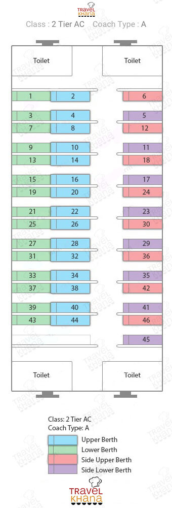
Train Coach Position And Seat Layout:-
First Tier AC Coach (1A):-

 First Tier AC Coach(1A)

Second Tier AC Coach(2A):- 

Second Tier AC Coach(2A

Third Tier AC Coach(3A):- 
Third Tier AC coach(3A)
Sleeper Class(SL):-

Sleeper class(SL)

Unreserved Second Class Compartment(GS):- 
Stands for Seating cum Luggage Rake(SLR):-

Bangalore(Namma) Metro Route from Kempegowda Majestic to RV Road

Bangalore Metro Route from Kempegowda Majestic to RV Road Fare and Timing

Planning to travel from Kempegowda Majestic to RV Road via Bangalore Metro? The metro offers a smooth, fast, and convenient route for commuters heading towards RV Road, which lies on the Green Line of Namma Metro. Starting your journey at Kempegowda Majestic, the central interchange station, passengers need to board a train on the Green Line going in the direction of Yelachenahalli. The total distance between Kempegowda Majestic and RV Road metro station is approximately 5.5 km, and the journey takes around 12 to 15 minutes.

The metro fare from Kempegowda Majestic to RV Road is affordable, typically ranging between ₹20 to ₹25, depending on card usage or token purchase. Trains run at regular intervals of about 8 to 10 minutes during peak hours, making travel highly efficient.

RV Road station serves one of the busiest academic and residential areas in South Bangalore. Whether you’re heading to educational institutions, residential zones, or popular eateries around the RV Road locality, the metro is the best way to avoid traffic and save time. Regular commuters should use the Namma Metro Smart Card for quicker access and discounted fares.

Get fresh food in train delivered directly to your seat with Travelkhana. We bring you food delivery in train from brands like Behrouz Biryani, Barbeque Nation, and more. We also serve at airports and offsites. Download the app today:

Fare25
Time14
Stations7
Interchange Stations0


Stations
■ Kempegowda Majestic
■ Chickpete
■ KR Market
■ National College
■ Lalbagh
■ South End Circle
■ Jayanagar
■ RV Road

Nearest Metro Station to Dr Ambedkar Institute of Technology

The nearest metro station to Dr. Ambedkar Institute of Technology in Bengaluru is Rajarajeshwari Nagar Metro Station, located on the Purple Line of Namma Metro. This station is approximately 1.1 kilometers away from the institute, making it a convenient option for students and visitors. The walk from the station to the campus typically takes around 15 minutes.

Alternatively, Vijayanagar Metro Station, also on the Purple Line, is another nearby option. While it’s slightly farther, some commuters prefer this station due to its connectivity and availability of public transport options to reach the institute.

For those traveling from other parts of Bengaluru, the Purple Line offers seamless connectivity. For instance, if you’re coming from Kempegowda Majestic Metro Station, you can board a train on the Purple Line heading towards Challaghatta and alight at Rajarajeshwari Nagar. From there, a short walk or a quick auto-rickshaw ride will get you to Dr. Ambedkar Institute of Technology.

The institute is situated in the Nagarbhavi area, which is well-connected by both metro and BMTC bus services. This ensures that students and faculty have multiple commuting options, making daily travel to the campus convenient and efficient

Nearest Metro Station to Vallabhbhai Patel Chest Institute

Nearest Metro Station to Vallabhbhai Patel Chest Institute

If you’re planning to visit the Vallabhbhai Patel Chest Institute, knowing the nearest metro station can make your travel much easier. The closest metro station to Vallabhbhai Patel Chest Institute is Vishwavidyalaya Metro Station, which lies on the Yellow Line of the Delhi Metro. The station is just about 1 kilometer away from the institute and is easily accessible via a short auto or e-rickshaw ride, or even a quick walk. The Vallabhbhai Patel Chest Institute is located in the North Campus of Delhi University and is one of the most prestigious institutions specializing in chest and respiratory diseases. With students, researchers, and patients visiting the institute from across India, metro connectivity plays a crucial role in hassle-free commuting.

By taking the Delhi Metro’s Yellow Line and alighting at Vishwavidyalaya, travelers can conveniently reach the Vallabhbhai Patel Chest Institute without worrying about traffic congestion or long travel times. Metro travel is not only cost-effective but also reliable and fast, especially in a city like Delhi.

So, whether you’re a student, a medical professional, or a patient, Vishwavidyalaya Metro Station is your best metro route to reach Vallabhbhai Patel Chest Institute efficiently.

Travelkhana is your go-to for food in train, delivering meals from leading restaurants like McDonald’s and Biryani Blues. Enjoy food delivery in train at 250+ stations, along with airports and offsite locations. Try the Travelkhana app now:

Route to reach Vallabhbhai Patel Chest Institute from Kashmere Gate Metro Station

Looking for the best route to reach Vallabhbhai Patel Chest Institute from Kashmere Gate Metro Station? If you’re planning to study at the reputed Vallabhbhai Patel Chest Institute and will be commuting regularly, the distance from Kashmere Gate Metro Station is just 4 km. It takes about 10 to 12 minutes to cover this distance by road. The nearest metro station to this Institute is Vishwavidyalaya Metro Station, located on the Yellow Line of the Delhi Metro.

From Vishwavidyalaya, the institute lies only 1.5 km away, which you can easily cover by walking or taking a short ride in an auto or e-rickshaw—reaching within 5 minutes. To travel conveniently, board the metro at Kashmere Gate and get off at Vishwavidyalaya. Then, proceed to the campus by walk or a quick local ride. Vallabhbhai Patel Chest Institute, located in New Delhi, is a distinguished postgraduate medical institute operated by the University of Delhi.

The institution specializes in research and education related to chest and respiratory diseases, making it a top choice for students focused on pulmonary medicine. The Delhi Metro makes the commute reliable, time-saving, and affordable for students and visitors alike.

Normal Fare (Rs.)20
Concessional Fare (Rs.)10
Time11 min
First5:59:00
Last0:27:03
From Platform0:00:00
Get down onLeft
#StationPhone
1Kashmere Gate8800793107
2Civil Lines8800793128
3Vidhan Sabha8800793127
4Vishwavidyalaya8800793126

Route to reach Vallabhbhai Patel Chest Institute from Noida City Center Metro Station

Normal Fare (Rs.)50
Concessional Fare (Rs.)40
Time48 min
First6:00:00
Last23:05:00
From Platform0:00:00
Get down onLeft
#StationPhone
1Noida City Center8800793155
2Golf Course8800793156
3Botanical Garden8800793157
4Noida Sector-188800793158
5Noida Sector-168800793159
6Noida Sector-158800793160
7New Ashok Nagar8800793161
8Mayur Vihar Extention8800793162
9Mayur Vihar Phase-18800793163
10Akshardham8800793164
11Yamuna Bank8800793165
12Indraprastha8800793166
13Pragati Maidan8800793167
14Mandi House8800793168
15Barakhamba8800793169
16Rajiv Chowk8800793133
Interchange
17Rajiv Chowk8800793133
18New Delhi8800793132
19Chawri Bazar8800793131
20Chandni Chowk8800793130
21Kashmere Gate8800793107
22Civil Lines8800793128
23Vidhan Sabha8800793127
24Vishwavidyalaya8800793126

Route to reach Vallabhbhai Patel Chest Institute from Vaishali Metro Station

Normal Fare (Rs.)50
Concessional Fare (Rs.)40
Time42 min
First6:00:00
Last23:05:00
From Platform0:00:00
Get down onLeft
#StationPhone
1Vaishali8800793236
2Kaushambi8800793235
3Anand Vihar8800793198
4Karkar Duma8800793199
5Preet Vihar8800793200
6Nirman Vihar8800793201
7Laxmi Nagar8800793202
8Yamuna Bank8800793165
9Indraprastha8800793166
10Pragati Maidan8800793167
11Mandi House8800793168
12Barakhamba8800793169
13Rajiv Chowk8800793133
Interchange
14Rajiv Chowk8800793133
15New Delhi8800793132
16Chawri Bazar8800793131
17Chandni Chowk8800793130
18Kashmere Gate8800793107
19Civil Lines8800793128
20Vidhan Sabha8800793127
21Vishwavidyalaya8800793126

Route to reach Vallabhbhai Patel Chest Institute from Rithala Metro Station

Normal Fare (Rs.)40
Concessional Fare (Rs.)0:00:00
Time26 min
First5:25:00
Last23:31:30
From Platform2
Get down onLeft
#StationPhone
1Rithala8800793120
2Rohini West8800793119
3Rohini East8800793118
4Pitam Pura8800793117
5Kohat Enclave8800793116
6Netaji Subhash Place8800793115
Interchange
7Netaji Subhash Place
8Shalimar Bagh
9Azadpur
Interchange
10Azadpur8800793123
11Model Town8800793124
12G.T.B. Nagar8800793125
13Vishwavidyalaya8800793126

Route to reach Vallabhbhai Patel Chest Institute from Huda City Centre Metro Station

Normal Fare (Rs.)60
Concessional Fare (Rs.)50
Time1:03 hr
First5:45:00
Last23:30:00
From Platform0:00:00
Get down onLeft
#StationPhone
1Huda City Centre8800793154
2IFFCO Chowk8800793153
3MG Road8800793152
4Sikandarpur8800793151
5Guru Dronacharya8800793150
6Arjan Garh8800793149
7Ghitorni8800793148
8Sultanpur8800793147
9Chhattarpur8800793146
10Qutab Minar8800793145
11Saket8800793144
12Malviya Nagar8800793143
13Hauz Khas8800793142
14Green Park8800793141
15AIIMS8800793140
16INA8800793139
17Jorbagh8800793138
18Lok Kalyan Marg8800793137
19Udyog Bhawan8800793136
20Central Secretariat8800793135
21Patel Chowk8800793134
22Rajiv Chowk8800793133
23New Delhi8800793132
24Chawri Bazar8800793131
25Chandni Chowk8800793130
26Kashmere Gate8800793107
27Civil Lines8800793128
28Vidhan Sabha8800793127
29Vishwavidyalaya8800793126

Bangalore(Namma) Metro Route from Indiranagar to Mysore Road

Bangalore Metro Route from Indiranagar to Mysore Road Fare and Timing

Looking to travel from Indiranagar to Mysore Road using the Bangalore Metro? The Namma Metro offers a smooth and time-saving journey for daily commuters and travelers alike. To reach Mysore Road, start your journey from Indiranagar Metro Station, which lies on the Purple Line. Board a train heading towards Kengeri, and you will directly arrive at Mysore Road Metro Station without the need to switch lines.

The total travel time between Indiranagar and Mysore Road is approximately 30 to 35 minutes, depending on the time of day and train frequency. Trains run every 5 to 10 minutes during peak hours, ensuring minimal wait time. The distance between these stations is around 15 kilometers.

As for the fare, a one-way ticket from Indiranagar to Mysore Road costs approximately ₹40. You can use a smart card for cashless travel and to save time at ticket counters.

Mysore Road is a significant metro stop, offering easy access to various landmarks and connecting routes in the western part of Bangalore. Whether you’re commuting for work, education, or leisure, the metro is the most reliable and efficient mode of transport for this route.

Fare40
Time28
Stations14
Interchange Stations0


#Stations
1■ Indiranagar
2■ Halasuru
3■ Trinity Circle
4■ M.G.Road
5■ Cubbon Park
6
■ Vidhan Soudha
7
■ M Visveswaraya
8
■ Kempegowda Majestic
9
■ City Railway Station
10■ Magadi Road
11■ Hosahalli
12■ Vijayanagar
13■ Attiguppe
14
■ Deepanjali Nagar
15■ Mysore Road

Nearest Metro Station to Don Bosco School of Management

If you’re searching for the nearest metro station to Don Bosco School of Management, the closest and most convenient option is Yelachenahalli Metro Station, located on the Green Line of the Namma Metro in Bangalore. The Don Bosco School of Management is situated in Kumbalgodu, on the outskirts of the city, and Yelachenahalli is the nearest point for metro connectivity.

From Yelachenahalli Metro Station, the distance to Don Bosco School of Management is approximately 14 kilometers. You can take a cab, auto, or BMTC bus to cover the remaining distance in 30 to 40 minutes, depending on traffic.

The Namma Metro is a convenient and time-saving option for reaching closer to the Don Bosco School of Management, especially for students and professionals commuting from different parts of Bangalore. You can board the Green Line from major stations like Majestic, National College, or Lalbagh and travel directly to Yelachenahalli.

Choosing the metro reduces travel fatigue, avoids heavy traffic, and provides a reliable and eco-friendly transport solution. While direct metro access to Don Bosco School of Management isn’t available yet, Yelachenahalli remains the most practical and efficient metro point for your journey.

Traveling long-distance? Don’t compromise on taste. Order food in train from Travelkhana. We provide food delivery in train from famous outlets like Haldiram’s, Faasos, and more. Airport and offsite delivery also available. Download now:


Bangalore(Namma) Metro Route from Jayanagar to Mantri Square Sampige Road

Bangalore Metro Route from Jayanagar to Mantri Square Sampige Road fare and timing

Planning a trip from Jayanagar to Mantri Square Sampige Road via Bangalore Metro? The Bangalore Metro makes commuting easy, especially between key commercial hubs like Jayanagar and Mantri Square Sampige Road. The journey starts on the Green Line of Namma Metro, offering a smooth and fast connection between the two locations.

From Jayanagar, board the metro heading towards Nagasandra. You will cross major stations such as South End Circle, Lalbagh, National College, and Majestic. In total, there are around 9 stations between Jayanagar and Mantri Square Sampige Road, and the travel time is approximately 20 to 25 minutes.

The fare for this metro journey is very economical, ranging between ₹30 to ₹40 per person. Metro trains on this route run at regular intervals of about 5 to 10 minutes, making it extremely convenient for daily commuters and shoppers visiting Mantri Square Sampige station, one of Bangalore’s largest shopping malls.

Mantri Square Sampige Road metro station is directly connected to the mall via a walkway, making it easy to access shops, restaurants, and entertainment. For a hassle-free experience, Bangalore Metro is the best option to reach this station comfortably and affordably.

Make every journey tastier with Travelkhana. Get food in train from premium restaurants including Oven Story, Barbeque Nation, and Biryani Blues. Food delivery in train, airports, and offsites just a tap away. Download the Travelkhana app:

Fare25
Time14
Stations7
Interchange Stations0


Stations
■ Jayanagar
■ South End Circle
■ Lalbagh
■ National College
■ KR Market
■ Chickpete
■ Kempegowda Majestic
■ Mantri Square Sampige Road


Nearest Metro Station to Dayanand Sagar College of Journalism

If you’re looking for the nearest Namma Metro station to Dayanand Sagar College of Journalism, then Banashankari Metro Station is your best option. Located on the Green Line of the Namma Metro, Banashankari Station is approximately 2.5 kilometers away from Dayanand Sagar College of Journalism. You can easily reach the college within 8 to 10 minutes via auto-rickshaw, cab, or even by walking if preferred.

Banashankari Metro Station offers seamless connectivity for students, faculty, and visitors heading to Dayanand Sagar College of Journalism from various parts of Bengaluru. Whether you’re commuting from Majestic, Jayanagar, or Yeshwanthpur, the Green Line ensures a convenient and affordable journey to your destination.

Dayanand Sagar College of Journalism ranks among Bengaluru’s respected institutions and offers quality education in media and communication. You’ll find the college in Kumaraswamy Layout, a vibrant locality that provides easy access to public transport.

Traveling via Namma Metro not only saves time but also helps you avoid the city’s notorious traffic. For anyone attending classes, seminars, or visiting the campus, using the metro to get near Dayanand Sagar College of Journalism is both practical and time-saving.

All About Indian railway – Food Delivery in Train